Cold Weather Health Alert Issued Across England as Snow and Ice Warnings Escalate
The United Kingdom is bracing for a significant temperature drop as authorities issue a three-day cold weather health alert for central and northern England. The alert, activated by the UK Health Security Agency (UKHSA), warns that vulnerable individuals could face heightened risks during this period of frigid conditions.
Health Warnings and Weather Advisories in Force
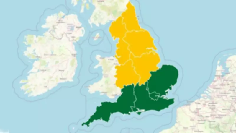
The UKHSA's health alert will remain in effect from Friday morning through Monday morning, covering extensive regions of central and northern England. This warning specifically highlights potential "minor impacts" on health services due to anticipated increased demand from those susceptible to cold-related illnesses.
Simultaneously, separate snow and ice alerts have been issued by meteorological authorities for Thursday and Friday, encompassing northern England and virtually all of Scotland. The Met Office forecasts widespread snowfall of one to two centimetres, with elevated areas above 300 meters potentially receiving up to 10 centimetres of accumulation.

Temperature Plunge and Precipitation Patterns
Friday is expected to be the coldest day of this weather event, with morning temperatures forecasted around 2°C (35°F) in Manchester and dropping to 0°C (32°F) in Glasgow under clear skies. This abrupt temperature decline follows an extended period of mild, wet weather that has characterized much of the winter season.
Sky News weather producer Chris England emphasized that this "incoming dip in temperatures would come as something of a shock after the long mild, wet spell." He explained that "the jet stream, which guides our weather systems, will move briefly south to end the week, allowing an increasingly northerly flow, bringing more wintry conditions."
Regional Rainfall Records and Weather Patterns
The cold snap arrives amid already exceptional precipitation levels across parts of the UK. Scotland continues to experience heavy rainfall, with yellow weather warnings remaining in force until midnight for extensive eastern regions and portions of the west coast. Remarkable rainfall statistics have emerged:
- Aberdeen has recorded 180% of its typical February rainfall
- Kincardineshire has reached 152% of average February precipitation
- Angus has measured 130% of normal February rainfall levels
The beginning of 2026 has brought seemingly relentless rainfall attributed to a "blocking pattern" in atmospheric conditions. According to Met Office data, 26 weather stations established new monthly records for January precipitation, while Northern Ireland endured its wettest January in 149 years of recorded weather history.
Geographical Variations and Weekend Outlook
It is important to note that southern regions of England are not covered by the current health alert, though they will experience the temperature drop. Meteorological experts anticipate that milder conditions should gradually spread from southern areas later in the weekend, potentially moderating the cold spell's intensity.
The combination of cold temperatures, potential snowfall, and already saturated ground conditions creates a complex weather scenario requiring public awareness and preparedness. Authorities continue to monitor the situation closely as these multiple weather systems converge across the United Kingdom.