Mounting Evidence Contradicts Trump's Claims on Minab School Bombing
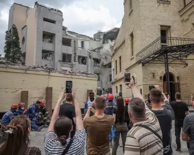
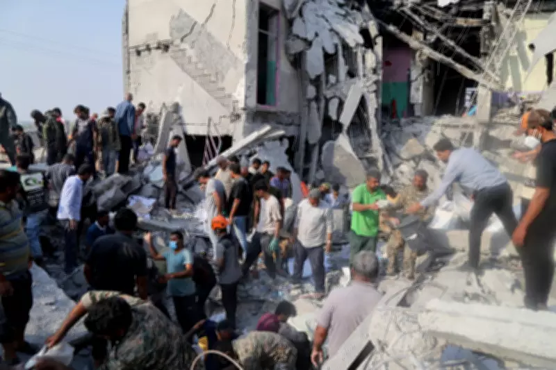
Rescue workers and local residents desperately searched through the rubble in the immediate aftermath of the devastating strike on Shajareh Tayyebeh primary school in Minab. The bombing on February 28th represents the worst mass killing event in the ongoing US and Israeli military campaign against Iran, claiming the lives of numerous children, predominantly girls aged seven to twelve. UNESCO has condemned the attack as a "grave violation" of established international law and humanitarian principles.
Presidential Accusations Without Evidence
On Saturday, US President Donald Trump publicly declared that Iran was responsible for the horrific school bombing. "In my opinion, based on what I've seen, that was done by Iran ... they're very inaccurate, as you know, with their munitions. They have no accuracy whatsoever. It was done by Iran," Trump stated emphatically. However, the president presented absolutely no verifiable evidence to support this serious accusation. Notably, his assertion has not been echoed or repeated by official spokespeople for the US military, who have maintained only that they are "investigating" the bombing incident.
Compelling Evidence Points to US Responsibility
A growing and substantial body of evidence now indicates that the strike on the Shajareh Tayyebeh primary school was actually carried out by United States forces. Multiple independent investigations have converged on this conclusion through various methodologies.

The School's Precise Location and History: The primary school was situated adjacent to a cluster of buildings forming the local Islamic Revolutionary Guard Corps (IRGC) naval barracks and support facilities. Cross-referencing verified videos from the bombing site with detailed satellite imagery confirms this location. Historical satellite records reveal that while the school building was once part of the broader IRGC complex, it has been completely walled off from the military barracks for at least nine years. For years, the facility displayed clear visual indicators of being an educational institution, including colorful murals on exterior walls and small sports playing fields, both visible in satellite images. There is no indication whatsoever that the school served any military purpose at the time of the devastating strike.
Verified Video Documentation: Several videos of the bombed school, verified as authentic, circulated on Iranian social media platforms immediately after the explosion. At least four distinct videos show the same site from different angles, sharing identifiable motifs like the school's distinctive colorful murals. One particularly revealing video shows the rubble of the destroyed school and then pans to display thick smoke rising over a fence from the direction of the adjacent IRGC base. This footage provided early indications that the bomb hitting the school was part of a series of strikes that also targeted the military complex next door.
Satellite Imagery Analysis: On March 4th, the first satellite images were released showing the aftermath of the strikes. These images clearly show the destroyed school building alongside four other demolished buildings in its immediate vicinity, all located within the walls of the IRGC complex. The aerial views provide crucial contextual evidence of the attack's scope and precision.
The Tomahawk Missile Revelation
On March 8th, Iranian state media agency Mehr released a video showing a missile striking a location in Minab. The investigative collective Bellingcat successfully geolocated this video, matching buildings, water towers, trees, and roads from the footage with satellite images of the Minab site. Their analysis determined that the missile had struck the IRGC compound directly adjacent to the primary school. Munitions experts have identified the weapon in the video as a Tomahawk cruise missile.

"Given the belligerents, that indicates it is a US strike, as Israel is not known to possess Tomahawk missiles," stated NR Jenzen-Jones, director of Armament Research Services, an intelligence consultancy providing munitions analysis to governments and NGOs. "The US is the only country involved in the Iran war to have this specific weapon. Despite various claims circulating online, the munition in question is clearly not an Iranian Soumar missile: the Soumar has a distinctive external engine located towards the rear, on the underside of the munition."
US Military Activity in the Region
While the United States has not explicitly admitted to striking the school or the adjacent IRGC barracks, officials have acknowledged conducting strikes in the general area. In a Pentagon briefing led by Pete Hegseth on March 4th, the US military shared a graphic illustrating where US and Israeli forces had conducted strikes during Operation Epic Fury. Although Minab is not specifically labeled on that map, one of the points marked as a US/Israeli strike location corresponds precisely to where Minab is geographically situated. The graphic notably marks where "Iranian strikes" had allegedly occurred according to US military assessments, with none marked in the Minab area. Broader US/Israeli intelligence briefings have reinforced this information, indicating that US forces focused initial strikes along Iran's southern coastline, where Minab is located, while Israeli operations concentrated on western regions of the country.
Debunking Viral Misinformation
Shortly after the bombing, numerous social media accounts propagated viral claims echoing President Trump's assertions, suggesting the school had been struck by a misfired Iranian missile. However, the photographs presented as evidence for this "misfire" narrative were actually taken approximately 994 miles away in the northern city of Zanjan, which has a much colder climate. The backdrop of the alleged misfire photo shows snow-covered mountains, while Minab lies on Iran's far warmer southern coast; satellite imagery confirms no snow-capped mountains exist in Minab's vicinity. In the foreground of the disputed image, signs for a dentist's clinic are visible, and experts have geolocated that specific office building to Zanjan. President Trump has not directly referenced this circulated image and has provided no additional evidence supporting the misfire theory.