Transport for London has released a remarkable series of three-dimensional maps that provide unprecedented insight into what lies beneath the capital's bustling streets. These fascinating schematics reveal the intricate layouts of some of London's busiest Underground stations, showing exactly how these complex transport hubs are organised below ground level.
Unveiling London's Hidden Underground World
While the London Underground is celebrated globally as one of the finest transport networks, navigating its labyrinthine passages can sometimes feel challenging even for seasoned commuters. Most Londoners believe they know their regular stations intimately, but the reality is that countless escalators, staircases and extended passageways mean there's far more to each station than initially meets the eye.
The fact that many stations operate entirely below ground makes understanding their configuration particularly difficult, even at stops used daily. These newly released 3D models offer a unique opportunity to visualise exactly how these underground complexes are structured.

Official Diagrams Reveal Station Secrets
Following a Freedom of Information request made in 2015, Transport for London has published its official diagrams showing every London Underground station's public spaces. These comprehensive plans encompass not just the train tunnels themselves, but also pedestrian corridors, staircases, escalators and other infrastructure elements.
The diagrams provide a compelling glimpse into the curves, corners and gradients that characterise each station's unique layout. We've selected some of the most recognisable and complex examples from across the network to examine in detail.
Bank and Monument: London's Most Extensive Station Complex
The interconnected Bank and Monument stations form what is arguably London's most extensive underground complex. Serving Central, District, DLR and Northern line trains, this sprawling network sees the Central line positioned at the Bank side, the District line at the Monument side, with the remaining two lines occupying the substantial area connecting these two stations.
Kings Cross St Pancras: Six-Line Interchange Hub
As one of the country's busiest stations, Kings Cross St Pancras serves as a crucial interchange point featuring four connecting Underground tunnels. An impressive six London Underground lines operate through this major hub: Circle, Hammersmith and City, Metropolitan, Piccadilly, Northern, and Victoria lines all converge here.
Liverpool Street: East London's Major Transport Centre
Functioning as East London's largest transport hub, Liverpool Street station connects the district to the broader capital through Overground, National Rail, and Underground services. The station accommodates Central, Circle, Hammersmith and City and Metropolitan lines, with only the Central line operating at deep level as clearly illustrated in the 3D diagrams.
Victoria Station: Right-Angle Line Configuration
Despite its relatively straightforward design compared to some other major stations, Victoria accommodates two lines running at right angles to each other. The lower-level Victoria line passes directly underneath the District and Circle lines, creating an interesting layered configuration that the 3D models reveal with particular clarity.
Waterloo: One of the Network's Most Intricate Designs
Waterloo station possesses one of the Underground network's most complex configurations, requiring three separate axonometric illustrations to completely demonstrate its arrangement. Victoria, Waterloo and City, Northern, District, Circle, and Bakerloo services all travel through this station via different routes, creating a remarkably intricate underground layout.
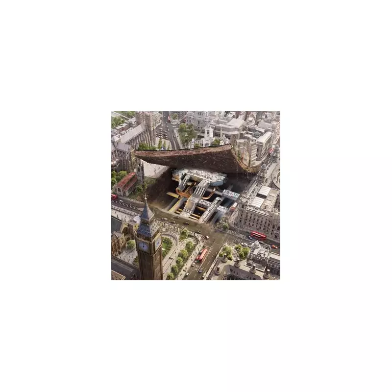
Westminster: Unique Lateral Perspective
Finally, Westminster Station incorporates Jubilee line tunnels alongside ground-level District and Circle line platforms. This station's specific layout representation adopts a somewhat different viewpoint from the others, providing a more lateral perspective that particularly highlights the multiple escalator systems familiar to regular users.

These remarkable 3D maps not only satisfy curiosity about what lies beneath London's streets but also provide valuable insight into the engineering marvels that keep the city moving. The detailed schematics reveal the hidden complexity of stations that millions of passengers pass through daily, often without fully appreciating the sophisticated infrastructure supporting their journeys.