
Cyclone Narelle Approaches Queensland with Category Five Force
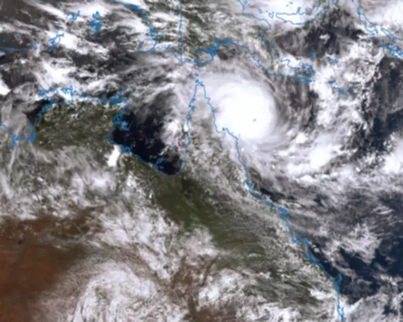
Satellite imagery from the Bureau of Meteorology shows Tropical Cyclone Narelle moving toward the Queensland coast as of 3.50pm AEDT on 19 March. The storm is predicted to make landfall early Friday morning as a category five system, coinciding with a high tide, heightening concerns for coastal communities.
Global Heating's Role in Fueling the Storm
Climate experts attribute the intensity of Severe Tropical Cyclone Narelle to global heating, which has elevated ocean temperatures in the Coral Sea. Andrew Watkins, a climate scientist and adjunct professor at Monash University, notes that the Coral Sea recently recorded its hottest months on record, with temperatures 1C to 2C warmer than average. "The Coral Sea is almost half a degree warmer than it was 30 or 40 years ago," Watkins explains, emphasizing that warmer waters act as fuel for cyclones by enhancing convection processes.
Impact of Higher Ocean Temperatures on Cyclone Formation
Cyclones require ocean temperatures above 26.5C to form, and the record warmth in the Coral Sea has facilitated Narelle's rapid intensification. Andrew Dowdy, an associate professor in climate science at the University of Melbourne, highlights that these conditions add moisture and heat to the air, promoting intense convection. Satellite images reveal lightning strikes around Narelle's eye, indicating the storm's strength over exceptionally warm waters.

Additional Climate-Related Risks
Beyond wind and rain, global heating exacerbates risks such as storm surges and coastal erosion due to rising sea levels. Watkins warns that higher sea levels can worsen inundation during cyclones, while increased atmospheric moisture leads to heavier rainfall. "A tropical cyclone sucks in moisture from a broad area and even when it is over land it has got that extra moisture available to rain out," he states, underscoring the compounded dangers.
Trends in Cyclone Frequency and Severity
While the number of cyclones in Australian waters has decreased since the 1980s, severe systems like Narelle are becoming more frequent due to climate change. Dowdy points out that weaker cyclones may decline, but buildings are often designed to withstand their winds, whereas category five storms pose greater threats. Australia's 2024 State of the Climate report confirms the Coral Sea as a hotspot for warming, aligning with these trends.
Historical Context and Comparisons
Queensland Premier David Crisafulli remarks that Narelle could be the biggest system in living memory for the region, noting that category five storms rarely cross the coast. The last such event in Queensland was Cyclone Marcia in 2015, while Cyclone Yasi in 2011 remains one of the state's most powerful storms. Comparisons are drawn to historical storms like Cyclone Mahina in 1899, which caused significant loss of life, highlighting the potential severity of Narelle.
As Narelle approaches, authorities urge preparedness, with the storm expected to bring destructive winds, heavy rain, and dangerous storm surges. The intersection of natural weather patterns and human-induced climate change underscores the growing challenges in managing extreme weather events.


