London is preparing for a potential winter blast as forecasters warn of a significant wall of snow heading directly for the capital to end the first working week of 2026.
The Snow Wall Forecast
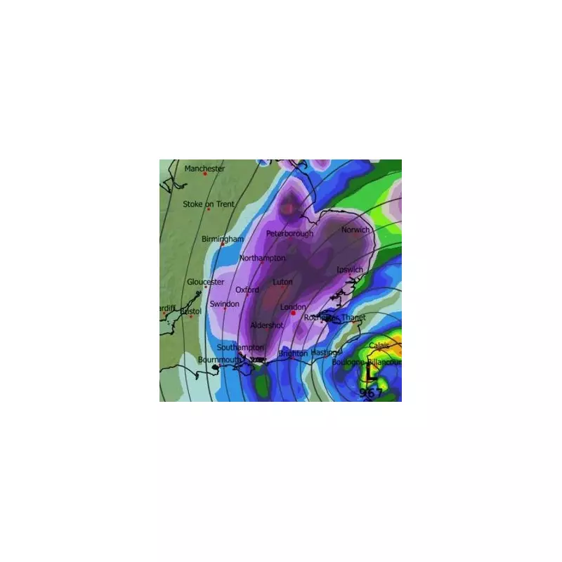
Meteorological data from WX Charts indicates a major snow event could sweep across the city around 9am on Friday, January 9, 2026. The striking weather map uses purple shading to denote the risk, with darker areas signalling heavier predicted snowfall.
The system is expected to arrive from the south-west, moving across southern England and the Midlands before progressing towards northern France. This prediction is supported by the BBC's long-range forecast, which hints at a deep low-pressure system bringing snow to the southern UK, followed by a blustery and chilly weekend.

Current Warnings and London's Forecast
This potential disruption comes as much of the UK is already under weather alerts. On Monday, January 5, the Met Office issued a series of yellow warnings for snow and ice across Northern Ireland, Wales, the Midlands, East Anglia, and parts of northern England. More serious amber warnings for snow are in place for parts of northern Scotland, indicating a risk of isolated communities, power cuts, and transport cancellations.
London, however, started the week clear of warnings. The BBC's daily forecast for the capital outlines a cold but clear beginning:
- Monday, Jan 5: High of 2°C, low of -4°C. Sunny with a gentle breeze.
- Tuesday, Jan 6: High of 4°C, low of 2°C. Sunny intervals.
- Wednesday, Jan 7: High of 5°C, low of 2°C. Sunny intervals.
- Thursday, Jan 8: High of 7°C, low of 4°C. Light rain.
- Friday, Jan 9: High of 6°C, low of 1°C. Light rain and a moderate breeze (with snow predicted around 9am).
Why Forecasting London Snow is Notoriously Difficult
The capital's reputation for unpredictable winter weather has a scientific basis. Weather expert Ian Currie explains that snow in London is highly dependent on local elevation and minor temperature fluctuations. "For every 50 feet or so you get higher up, there is an increased likelihood of an extra day of snow," he stated.
This means areas like Sanderstead in South Croydon can experience ten more days of snow annually than parts of north Croydon, just a short distance away. Similarly, higher ground like Biggin Hill sees more snow than Streatham. A difference of just a few degrees can turn predicted snow into rain, making precise local forecasts a complex challenge.
As the week progresses, Londoners are advised to monitor the latest Met Office and BBC Weather updates closely, as the path and intensity of the predicted Friday system could still change.