
Emergency services have defended the timing of alerts issued to holidaymakers caught in what has been described as an "unprecedented" deluge along Victoria's Surf Coast, which saw cars washed into the ocean and hundreds of people displaced.
An Unprecedented Deluge on the Surf Coast
The chaos unfolded on Thursday after the region around Wye River and Lorne was hammered by an intense downpour. The Bureau of Meteorology recorded a staggering 180 millimetres of rain in just six hours, causing the Wye, Kennett and Cumberland rivers to flash flood.
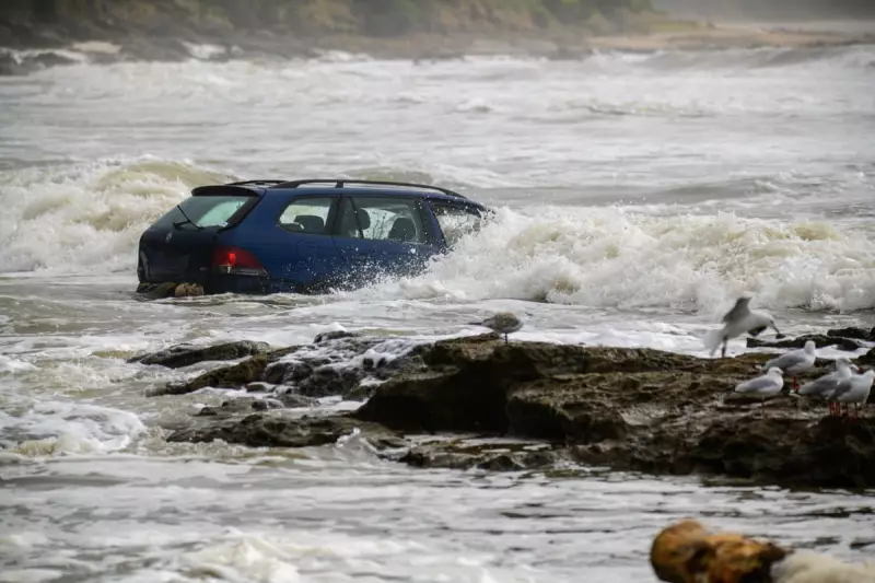
Dramatic photographs showed waves crashing into vehicles that had been swept from a local caravan park out to sea. The force of the water destroyed dozens of vehicles and flooded campgrounds, displacing approximately 400 people, including those staying at the caravan park.

Colac mayor Jason Schram questioned the level of warning provided, asking how such extreme rainfall could not have been predicted. "It's pretty messy, with mud, debris and, of course, everyone's personal belongings, caravans, camping gear," he said.
Authorities Insist Warnings Were Timely
However, authorities have pushed back against criticism, insisting their response was swift given the extraordinary nature of the event. Dharni Giri, a spokesperson for Victoria's State Control Centre, stated that more than 10,000 people in the area received a text alert urging them to move to higher ground.
"In our eyes, warnings were not issued late," Giri said. "It was an unprecedented weather event, and our response was pretty incredible when you think about how quickly it happened." She credited the rapid mobilisation of State Emergency Service crews and other partners for preventing any deaths or serious injuries.
The Bureau of Meteorology explained that it escalated warnings as observations climbed rapidly. A severe thunderstorm warning was issued at 11:57am AEDT after 45mm of rain fell in one hour at Mount Cowley in the Otway ranges. This was soon upgraded to a warning for intense rainfall.
More Severe Weather Forecast for NSW South Coast
Meanwhile, the focus is shifting north as meteorologists warn of further dangerous conditions. Senior Bureau of Meteorology forecaster Angus Hines said more flash flooding is expected across southern parts of New South Wales and Victoria in the coming days.
A severe weather warning is in place for Friday, stretching from Wollongong to the Victorian border. The Illawarra and NSW south coast could see between 150mm and 200mm of rain from Thursday afternoon through to Saturday night, accompanied by damaging wind gusts of up to 100 kilometres per hour.
"Where heavy rain occurs... there's likely to be disruption and delays to travel and transport, including road closures," Hines warned. The wild conditions are also expected to create very rough seas, impacting boat travel and potentially affecting flights.
Ongoing Bushfire Threat Complicates Recovery
The severe weather brings a mixed blessing for fire-ravaged parts of Victoria. While the cooler, wetter conditions have helped contain major blazes like the Ravenswood/Harcourt and Wyperfeld national park fires, seven significant fires continue to burn across the state.
Giri noted that more than 411,000 hectares have been burnt, and a state of disaster remains in place until 8 February. She urged communities to stay vigilant, as more hot weather is predicted for next week, though not at the catastrophic levels seen recently.
The extreme events underscore warnings about climate volatility. A report from the Insurance Council of Australia in October highlighted the nation's growing vulnerability, a concern echoed by the World Meteorological Organisation's confirmation that global temperatures continue to soar well above pre-industrial levels.


